Having arrived in Leh earlier than my reporting
day for a YHAI bicycle trek, I had 2 days and a night to myself
before reporting at the YHAI camp; plenty of time to explore the area. My trip was
very localized as I did not have my own transportation. You may be able to go
farther and see more places than I could in the same amount of time if you had your own means of conveyance. I am being
picky about the pictures I put up here since you can easily find the ‘usual suspect’ pictures online.
My journey to Leh was in
itself an adventure. 3 options exist to make it to Leh: air; road; road+rail. Although few would choose the last option since it is the longest, for me
it sounded more interesting to do.
I found a place to crash for the night, dropped off my
backpack, and headed out. Leh Palace was the first place I visited. There's a road
leading up to the palace but what’s the fun in driving up to it? Nothing to comment about
this place as there’s a lot already said online.
 |
An intricately carved wood window in one of the homes lining the
walk up to the palace.
|
 |
A wall painting inside the palace by a long forgotten painter.
|
 |
A terrace in the Leh palace.
|
Further up from the Leh Palace on Namgyal (Tsemo) hill is the
so called ‘Castle at Tsemo’. Although the climb up to it is a bit steep, it
serves as a good acclimatization exercise. Although the castle was locked, the panoramic
views of Leh Town and the surrounding mountains from up there are worth it. Time your visit in such a way that you reach there before sunset. If the
atmosphere and cloud happen to be in fortuitous agreement with the Sun, you
will be treated to some eye candy.
 |
A view from Tsemo Castle. Weather’s a lottery and I was lucky to have won
a golden sunset.
|
 |
Another view from atop the castle looking towards Stok Kangri mountain.
|
 |
Sunset view from the castle.
|
That was all I could cover in the half day I had. Started early the next day.
 |
There are many
delightful places in Leh to have your breakfast (lunch & dinner too).
|
 |
I then walked up the stairway to Shanti Stupa. This arrow mark points
to….
|
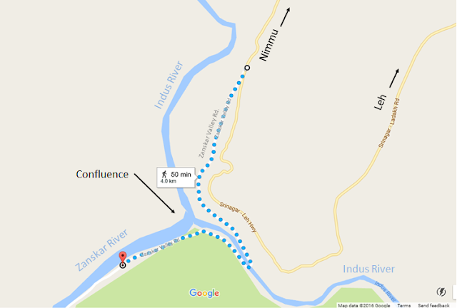
What next? I wanted to visit the confluence (sangam) of the Indus and Zanskar rivers.
I could’ve rented a motorbike to ride around Leh and is something I suggest you do simply because it is such a pleasure to ride these smooth, open
roads. But, I decided to try my luck hitchhiking. First, I hitched a ride in a tipper
truck to exit Leh town, then rode a local bus 20 km to a place that was
close to Nimmu village. However ,you musn’t actually ride all the way into Nimmu but request to be dropped off on the highway from where a road leads up to
the confluence and beyond. The map below makes this clear. (Nimmu village, 28
km from Leh, is itself a tourist and adventure destination. Check it online.)
 |
My walking route to the
confluence and beyond across the Indus.
|
 |
Caught the
local bus from here to get to near the confluence.
|
A decent walk lay ahead of me to get to the confluence
that took me about 1.5 hours (longer than what Google maps indicates. But,
I was walking slowly. That’s why rent a bike).
The above picture shows the point where the two rivers meet:
Indus (L) and Zanskar (R). Fast-flowing Zanskar is muddy (all
year round?) whereas the Indus would be tinged bluish/greenish. Unfortunately,
unseasonable rains in the mountains that year turned the Indus muddy. The
resulting visuals although not pleasing to the eye (Google for some nicer pictures) was nonetheless a sobering sight.
 |
Now, the view from the other side: Zanskar (L) and Indus (R). But how do I get down there?
|
Having walked to the other side of the Indus, I discovered that
there's no path to go down to the confluence. So I kept walking down the
road (till a signboard welcoming visitors to the Hemis High Altitude
National Park) to see if I could find one. All I found was a path to the banks
of the Zanskar. There was also no way to walk along its banks to get to the
confluence. Nonetheless, I suggest you make it this far as it was one of
the most beautiful places to be for many reasons. Here are the pictures.
 |
This was the only safe spot I found to barely step into the fast-flowing
Zanskar-- the river had been considerably slowed as it was forced to run around
two huge protruding rocks.
|
 |
What type of plant is that?
|
 |
Took this snap just before stepping off the lunar lander (yeah right).
|
 |
The sand banks took on this amazing shape. No doubt sculpted by Vayu and
Varuna (or Anemoi and Achelous; or benevolent Jinns)?
|
 |
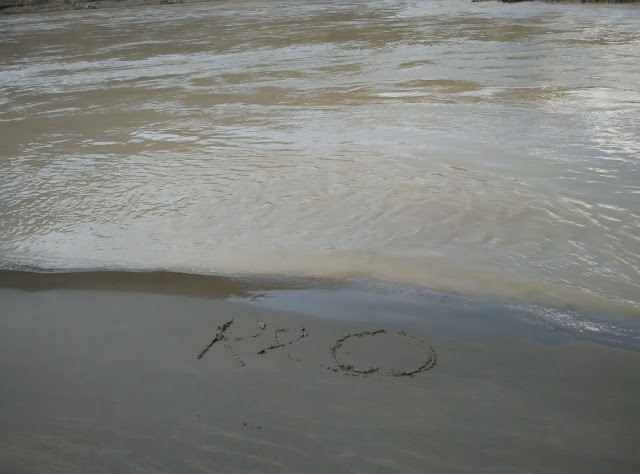
“RO”
|
 |
My travel friend of many years.
|
After spending some time on Zanskar’s banks, I retraced my
steps back to where I was closest to the confluence. As observed, there was no designated
path to get down from the road to the confluence, and it may have been for a good
reason too as that place is not the safest in the world. With two big rivers
crashing disagreeably into each other, there's no saying how robust the sandbank
would be down there. Perhaps the clayey surface is only tenuously held together?
Stand on it and you will go crashing into the waters? (I exaggerate of course). There was only one
way to find out: I scrambled over the rocks and made my way down. I did use a
technically sophisticated precaution though: Poking a stick into the clay to check
if it will hold my weight. It did, and so I went as close as I dared to
the confluence - keeping a respectable
distance of ~5 feet from the surging waters.
 |
Perhaps it would’ve looked nicer if there was less dirt in the water. At
this distance, you could see the raging currents crashing and forming
formidable eddies. Worth seeing.
|
 |
Moon rock. (“Honestly!” [Austin Powers])
|
As I began to retrace my steps contemplating the 1.5 hour
walk to the Srinagar-Leh Highway, a biker came up behind. I expected
that he too would just pass by, but he didn’t. He offered me a ride and that's how I got to experience what
it feels like to ride (pillion) a Bullet on those magnificent roads of Leh.
That was it. This day was ending, signaling it was time
for me to collect my backpack and report to the YHAI base camp.
Also called Reasi
fort, Zorawar fort was placed under the command of General Zorawar Singh (1786-1841)
of the Dogra Dynasty while he was in the employ of Maharaja Gulab Singh of
Jammu. Referred to as the "Conqueror of Ladakh" and "Napoleon of
India", the General was known for his expeditions against the Chinese rulers in
Tibet and Ladakh and the Durrani rulers in Baltistan. He died in Tibet
while making his way back from the Tibetan plateau.
 |
On the way to the YHAI camp in Skara I came across the Zorawar Fort (seen
here in twilight). This part of the journey had ended. Another was set to
begin.
|
* * *
Thanks for your time reading through :)


No comments:
Post a Comment