Wednesday 31 August 2016

Khardung La: A solo ride by bicycle

I had just participated in my first ever cycling trek – ~100 km over 4 days in Leh as part of the Youth Hostels Association of India (group LMB9). As satisfying as this was, I still had a lingering feeling of “some unfinished business”. Perhaps a bigger adrenalin rush was what I needed and felt a ride up to Khardung La (“La” is Tibetan for “Pass”) may just be it.

For those unawares, the road leading up to this pass is claimed to be the “highest motorable road in the world”. While this claim may have without doubt been valid at some point in the past, it probably isn’t anymore. (A pedantic discussion of this point is at the end of this post.) Hence, the Border Roads Organization (BRO) signage at the pass that makes this claim may have been true once upon a time and has simply not been updated. However, I have no problem with this state of affairs because those who make it to the pass revel, blissfully unaware, in taking their snaps standing in front of the said signage and feeling happy (isn’t that the point of life?). Moreover, there is a lot of satisfaction and perhaps a sense of some personal achievement against the odds for the biker who makes it to that altitude, irrespective of any superlative attached to that place.

Three options exist to make it up there: By four-wheeler (4WD or 2WD), motorized two-wheeler, or bicycle. From what I heard from some of the YHAI folks I met earlier, it is quite an exhilarating experience riding a two-wheeler, especially if it is an Enfield Bullet™, to the top. For me though, riding a bicycle fit my needs better.

I am neither a regular cyclist nor do I have much experience in high altitude trekking or cycling. In the days immediately preceding, I had gotten as high as 13450 ft. (bicycling with YHAI to Fotu La (this pass is the highest point between Srinagar and Leh on the highway connecting the two), and 17688 ft. (by four-wheeler to Chang La on the way to Pangong Tso Lake in Eastern Ladakh). Now, after a day’s rest from the YHAI tour, I wanted to bicycle up to Khardung La @18380 ft. It was a less than ideally prepared leap into unfamiliar territory as I was unsure about both the logistics involved (no more YHAI to come to the rescue) and about how my body would cope with the ever thinning air. (For a pedantic discussion about what exactly do people mean by “thin air”, see the end of this blog post.)

Khardung La being a military post, there is no provision for civilians to stay there. Hence, you’ll have to ensure that this is a day-trip -- both legs of the journey need to be done and dusted during daylight hours. Riding in the dark may be too dangerous and the weather may become too cold. There may also be no passing traffic in case you need help. (Later, I suggest why you may consider doing at least a part of the downward journey in the dark provided you are carrying artificial lights.)

A note about road surface conditions: At the time of my trek (mid-Aug 2015), I encountered 3 types of surfaces: asphalt, pavement foundation, and none (pictures below):
  1. The smooth asphalt road from Leh to South Pullu on the first leg of the upward journey was an absolute bliss to ride (especially on the way down).
  2. The road after South Pullu was still under construction where only the pavement foundation (before it receives asphalt) was ready. Barring the odd pothole, this surface did not offer any more challenge than an asphalt road would (well, that may not be entirely true given the greater surface friction that one would have to overcome).
  3. The paved foundation road had largely ended after a few kilometers (don’t recall how many) from which point on it was a “road” riddled with loose rock and tops of buried boulders jutting out, mixed in with some level stretches, interspersed by the occasional brook of snow melt. It was a bit uncomfortable riding this surface as it posed a higher risk of losing one’s balance (although any fall would not be a high speed one since you would be riding at a crawling pace anyways).
Just for the heck of it, I set myself some ground rules for the ride. Rule #1: I wouldn’t walk a single inch of the distance (as in, get off my bike and walk with it). I was set on sticking to it, and I did. Rule #2: I won’t sit down every time I stop for a rest or a sip of water (excepting the lunch break). I would only rest while standing. I broke this rule once.

A few facts: Leh to Khardung La
  • Elevation change from Leh town to Khardungla La: 6601 ft. (11483 ft. to 18380 ft.)
  • Distance by road: 40km (but only 16km as the crow flies a.k.a. the great-circle distance)

Here was my experience. I managed to rent a suitable bicycle the night before. Following a light sleep, I hit the road at 6:00AM. But, after just 2 km, and 0 altitude gain I began to struggle which was probably down to the fact that my body had not warmed up sufficiently and, frankly, nor had my mind. But after reading two road signs that showed where I was heading, the gears in my mind shifted and I started to make smoother progress.

A road sign just outside Leh town pointing out the way (to the right) to "Khardongla"

The first BRO sign indicating where one is headed.

Cycling for the first 2 hours on smooth asphalt road, I managed to cover 20 kilometers (km). Distance remaining to cover? Just 20 more km. You’d think I would reach the pass in another 2 hours (by 10:00AM). Wrong. Excluding an hour for a lunch-cum-rest stop at South Pullu, it took me another 6 hours and 20 minutes to cover the remaining 20 km!  In total, it took me 8 hours and 20 minutes of riding time to get from Leh to Khardung La. Jeez! Google Maps estimates that in 2016 it would take a person 10 hours to walk that distance (1 hour by motorized vehicle). A group journeying to this pass way back in 1900 state that it took them 10 hours to march from Leh to the pass. (Although they did mount yaks from the 14000 foot point. Cheeky. More on them later in the post.) In other words, someone walking could have easily overtaken me while other bicyclists would have left me far behind. Indeed, I came across a couple of riders at the start of my ride whom I never once saw again. They were gone like the wind. There were at least three other bicycle riders on this day (a foreign couple included) that I could spot in the far distance behind me.

As I gained altitude the air started to thin out further, the effect of which I began to feel the most from South Pullu onwards. There were moments of agony (that’s perhaps too strong a word to use) showing just how poor my cardio fitness level was. Furthermore, the cold at this height started to bite despite it being a brilliantly sunny all throughout the day. I found myself beginning to take far too many breaks to catch my breath. But the tough part was to not know how much further I had left to go. Such knowledge normally acts as a motivator. I had the opportunity to ask passing traffic for this information, but chose not to. Instead, I made a mental guestimate (it turned out to be some way off) and kept moving.

When I was about an hour away from the pass, I hit the dreaded “wall”. I felt a bit too exhausted to go on and a slight bit disheartened about not knowing how much distance I had left to cover. I was also rationing water against my thirst. (Obviously, I had not filled up sufficiently at South Pullu having underestimated the quantity I would end up consuming.) I parked my bike and sat on a rock. Rule broken. I sort of zoned out for a few seconds (which was a wee bit foolish and scary in equal measure as I was sitting on the cliff side of the road) before finding my bearings again and carrying on.

An hour later, I reached the pass. How does it feel? Like almost all things in life, it is better left to be experienced. No words would come near enough to describe one’s feelings; you must discover for yourself. Personally, the tough surface conditions that I was lucky enough to encounter made my ride all the more memorable than having to bicycle all the way along an asphalt surface.

The views from the pass were nice. The road beyond descends into the Nubra valley and continues along the Nubra river. In the far distance is the Siachen Glacier (not sure if it is visible to the naked eye from Khardung La).  Located at the pass itself are a small military museum, a few commemorative plaques, and an operational café for those in need of a hot beverage. There isn’t much else to the place. Moreover, it is not recommended that you stay too long up there (30 minutes is the recommended time) due to the thin air. Nor is there any accommodation to spend the night as it is a military outpost.

Leave, you must.

Ride Summary:
  • Start from Leh @ 06:00 hours.
  • Half distance (20 km) covered in 2 hours.
  • Lunch-cum-rest stop for an hour @ South Pullu (arrival time not recorded), the only inhabited place between Leh and Khardung La.
  • Reached khardung La @15:20 hours
  • Depart Khardung La @ 16:00 hours and reached Leh @ 18:15 hours
  • 8 hours and 20 minutes: Total time (excluding an hour’s stop at South Pullu) but including a few 1 or 2 minute breaks along the way. 


What’s the weather like at Khardung La?

The undated note posted inside the small museum at the pass sheds some light. Summer temperatures are a balmy 20 degrees Celsius. However, in winters the pass experiences snow accumulation of ~10 feet and minimum temperatures of minus 40 degrees Celsius. While your average bicycling speed going up can reach as high as 1 km per hour (!), wind speeds can reach up to 100 kmph. Despite such conditions, given the security implications of these border lands, the pass is kept open round the year by “men (and women?) and machines of 16 Border Roads Task Force of Project Himank, Border Roads Organization”. Kudos to them.


A few things to consider in planning a solo ride. Please bear with the mundane details:

1) Find a suitable ride. There are many available on rent in Leh, even foreign brands (Giant™, Trek™, etc.) The problem really is to ensure that you get functionally robust equipment (no loose brakes, unreliable gear mechanism, grip-less tires, and the like). Since I wasn’t too knowledgeable about these matters, it was important for me to find a renter who is keen to make sure the equipment he is handing over to me is in absolutely fit for the ride envisaged. You may be accommodative on these criteria if you were renting a bike for joy rides around town but not when you are undertaking a solo ride to a place where you are not going to find support facilities in case of trouble. I was lucky to find a renter who was careful and patient in ensuring I got a good bicycle.
a) It should be a mountain bike. (I chose a Trek 3700.)
b) Lowest would be the only gear you would likely use to go uphill (unless you want to challenge yourself with the next higher gear). So, make sure the bike has no problems in that gear position. You can shift to higher gears downhill, but be extremely careful about the speeds you want to attain.
c) Carry a puncture kit. Some bicycle renters claim that in case of any flats you just need to call and they will come and fix it. However, I wouldn’t bet on it because: (i) it may take them too long to come and consequently you may have to abandon your journey due to time constraints (it may get dark); (ii) an unscrupulous renter will have no intention of keeping his word; (iii) phones may not work so you can’t call anyone. The best thing to do therefore is to carry a puncture kit. I asked for and took along the following:
> a portable air pump (I ended up having to carry a heavier full-sized pump rather as a palm-sized one as the latter was unavailable);
> spare tube;
> screwdriver (not the sharp-edged, flat type that may damage the tube but a blunt, “curved lip” one; see picture);
> knowledge: Learn how to fix flats and practice it. With the right kind of mountain bike it should be fairly easy to extract/mount the tire.
d) Obviously, ensure you have safety equipment: Helmet, knee guards, etc.

2) Carry enough water but not so much that you end up carrying additional weight than is necessary. Since a liter of water weighs 1 kg, the lighter your equipment (the bicycle mainly) the more liquids you can carry. There will be one place (South Pullu) on the way where you can get a refill. So, plan accordingly.

3) Carry enough food/food supplements and packs of ORS (oral rehydration salts). I did carry a few chocolate bars and fruits but underestimated the quantity I would end up consuming during the ride. So, it’s better to err on the side of caution and carry more. In fact, choosing to carry energy bars/gels (such as by Cliff) rather than say fruits has the added advantage of being lighter in weight!

4) Carry some warm clothing. Though your body will be warmed by the physical exertion from cycling, I still suggest you carry warm clothing as: (1) the weather can turn on a dime; (2) sometimes you may end up going so slow (either to conserve energy or maybe you are unable to go faster) that your body doesn’t warm up enough so that you don’t feel the cold around you (especially if it’s windy).

The rented equipment.


Hello friend. Will I see you again in life? (Or will you see me again?) 

In memoriam.

Lunch at South Pullu

Asphalt road

Pavement foundation road. 

A dark-colored mountainous outcrop south of the pass that stands out in stark contrast to the surrounding greyness. Is possibly not basaltic rock, what is it then?

Construction workers toiling away near the pass.

Ignoring the blue sky, this place looked to me like moonscape.

A beautiful old-school ‘shaded relief’ map with the light and shade producing a three-dimensional effect. Interestingly, it is drawn at a slight angle that  helps bring out the beauty of the landscape.Two of these maps hang in the small museum at Khardung La pass. This one depicts the mountains, lakes, and rivers of Ladakh, Aksai Chin, and China. I feel it was rendered by hand by a cartographer whereas such maps are today computer generated. Khardung La is located slightly to the left of the map’s center and right below it is Leh. As you gown down this mountain range, you'll see Chang La pass (bottom right corner). 

Coda

While it took me 8.33 hours to go up, the ride down took a miniscule 2 hours and 15 minutes. You can do it a lot faster if you do not plan on stopping anywhere for photographs or to admire the scenery. I reckon that if you don’t, you can come down in about an hour.

Tip: I suggest that you make a biased tradeoff. For your adrenalin rush, speed all you want on the smooth asphalt stretches. However, don’t do it too often and for long stretches (like I did). Instead, allocate more time to stopping along the way to admire the beauty of the sky, mountains, and a setting sun (the last one can happen if you time your descent well enough). A compelling reason to do so is that, in my opinion, on the way up your mind and body would be far too preoccupied with being focused on the effort of riding the bike. Consequently, you would hardly get to admire or appreciate much of the scenery while gasping for breath. So, reward yourself on the way down.

Tip: I make this suggestion to thus split your time on the way down because you only get one shot (unless of course you want to again bike all the way back up.) There is another way though. For your second trip to Khardung La, pop your bicycle into a pickup truck, motor up to the pass, and then ride down, this time as often and as fast as you can dare to. There are tour operators who will arrange for this experience. (I didn’t try this). 


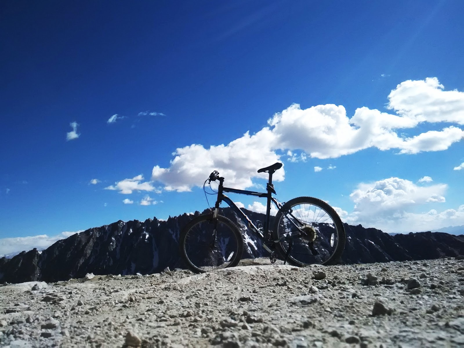
The bike at Khardungla Pass.

“RO”

To date, 869 army personnel have laid down their lives for the country while serving on the glacier, one of whom was Major N. Jawahar Reddy <nda.nic.in/martyrs.html> of 2/8 Gorkha Rifles.


‘Engineer War Memorial” dedicated to the machines and men (and women?) of the Indian Army’s 201 Engineer Regiment who completed the work in 1973 making it the then highest motorable road in the world.

An astoundingly azure sky. Not artificially enhanced.

On the way down.

On the way down.

Shanti Stupa coming into view on approach to Leh town.

Leh palace coming into view on approach to Leh town.

A quaint little mosque glowing in the setting sunlight just as I enter Leh town.

A solo celebratory dinner in Leh town to mark the completion of a solo ride.

For some perspective:


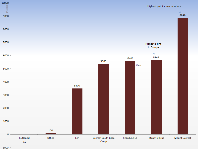
“World’s highest motorable road”? Which “world” are we on?

For a land of superlatives (world’s highest LPG bottling plant*, world’s highest research station**, world’s highest salt water lake***, world’s second highest astronomical observatory****, world’s highest battle ground^, world’s highest helipad^^, world’s highest airstrip^^^, world’s highest….phew!) there’s one causing a fair bit of confusion among readers and blissful denial ;) among riders and shutters bugs who make it there: The “world’s highest motorable road” (additionally complicated by how one defines “motorable”).

‘Ladakh’ literally means the ‘Land of many passes’ (pass = “La” in Tibetan). And so it is. Here are a few notable ones. Try deciding which is the “highest”:
  • Marsimek La: 18635 ft. as per an undated note in the museum at Khardung La (unreferenced information on Wikipedia places it at 18314 ft.). It notes “…though higher than Khardung La, [Marsimik La] is not ‘motorable’ as it allows very limited move by four wheel drive vehicles over a rough track”. As of 2016, I am not aware if a pucca  road has been laid or not. And, depending on how you choose to define “motorable”, this may well and truly be the highest in the world. 
          There's an insightful and informative write up about this pass on 60kph.com so no point in me commenting further not least because I have not been there (yet).
  • Khardung La: 18380 ft. as per on-site BRO (Border Roads Organization) signage, else 17582 ft. as per a 2006 report by the Institut Cartographic de Catalunya (link for relevant documentation is on Wikipedia.) Interestingly, Fanny Bullock Workman, the mountaineer and cartographer, in her book ‘The Ice World of Himalayas’ mentions that “Kardong” was at a height of 17574 ft. (An extract from this fascinating book was posted in the aforementioned museum. You can also find it in the public domain at archive.org). She trekked across the pass way, way back in 1900. Do check out the Wikipedia page dedicated to her.
          When I was riding on this road in Aug '15, work to resurface it with asphalt from South Pullu to Khardung La was ongoing. Those who rode it during this period (especially by motorbike or bicycle), you were lucky to have experienced a “tough” and therefore fulfilling ride. If the asphalt has since been laid, the challenging conditions no longer exist.
  • Chang La: 17688 ft. (which doesn’t translate to the 5360m you will see mentioned on BRO signage at the pass! So, pick your number.) This pass is encountered on the road leading to Pangong Tso Lake. Asphalt road.
  • Outside Ladakh:
          Mana La: 18192 ft. in Uttarakhand (Source: Wikipedia).
          Semo La: 18258 ft. in Tibet (China). Apparently the track is unsurfaced. Wikipedia uses the rather broad exegetic “highest vehicle-accessible pass” to describe it. (Source: Wikipedia).

*1180 ft. on the Srinigar-Leh highway; 
**17582 ft. @ Chang La pass; 
***Pangong Tso [I can’t confirm if it’s the world’s highest, but I can certainly confirm it tastes salty :)]; 
****14764 ft-based optical observatory @ Hanle as per Wikipedia; 
^Siachen glacier where India maintains a permanent military presence @ over 20,000 ft.; 
^^~21000 ft. @ Point Sonam as per Wikipedia; 
^^^16614 ft. @ Daulat Beg Oldi (DBO). The DBO Advanced Landing Ground near the Line of Actual Control (LAC) is no doubt a gravel air strip but the Indian Air Force managed to land a gargantuan C-130J Super Hercules transport plane (wingspan of 132 ft., that's longer than a Boeing 737's at 111 ft.). 


”Thin” air? Is dieting therefore better practiced in the mountains?

What exactly does one mean by “thin “air? This was news to me: The percentage of oxygen in the air we breathe in (i.e., inspired air) is constant (approx. 21%) irrespective of the altitude. What really matters therefore is the atmospheric pressure, the weight of the air above us. So, obviously, atmospheric pressure and hence inspired oxygen pressure falls (almost linearly, allowing for variations in weather conditions) with altitude gain: 101kilopascals (kPa) at sea-level, 50kPa at Khardung La, and 30kPa atop Everest (the latter two are approximations based on the chart below).  How this makes life difficult for us humans is that the lower atmospheric pressure decreases the partial pressure of inspired oxygen and hence the driving pressure for oxygen exchange in our lungs; in other words, the decreased driving pressure of oxygen from our alveoli (the air cells of our lungs) into the blood in our arteries insufficiently oxygenates the blood. This’s just one of several problems your body will encounter. Enough of the science lesson. For more information refer to this page on the NIH website. 

Chart showing the relationship between altitude and inspired oxygen pressure. (Sourced from Wikipedia)


* * *

Thanks for your time reading through :)

Tuesday 30 August 2016

Leh: A day-trek in and around the town

Having arrived in Leh earlier than my reporting day for a YHAI bicycle trek, I had 2 days and a night to myself before reporting at the YHAI camp; plenty of time to explore the area. My trip was very localized as I did not have my own transportation. You may be able to go farther and see more places than I could in the same amount of time if you had your own means of conveyance. I am being picky about the pictures I put up here since you can easily find the ‘usual suspect’ pictures online.

My journey to Leh was in itself an adventure. 3 options exist to make it to Leh: air; road; road+rail. Although few would choose the last option since it is the longest, for me it sounded more interesting to do.

I found a place to crash for the night, dropped off my backpack, and headed out. Leh Palace was the first place I visited. There's a road leading up to the palace but what’s the fun in driving up to it? Nothing to comment about this place as there’s a lot already said online.

An intricately carved wood window in one of the homes lining the walk up to the palace.

A wall painting inside the palace by a long forgotten painter.

A terrace in the Leh palace.

Further up from the Leh Palace on Namgyal (Tsemo) hill is the so called ‘Castle at Tsemo’. Although the climb up to it is a bit steep, it serves as a good acclimatization exercise. Although the castle was locked, the panoramic views of Leh Town and the surrounding mountains from up there are worth it. Time your visit in such a way that you reach there before sunset. If the atmosphere and cloud happen to be in fortuitous agreement with the Sun, you will be treated to some eye candy.

A view from Tsemo Castle. Weather’s a lottery and I was lucky to have won a golden sunset.

Leh town at sunset was melancholic/mesmerizing (make your pick). Many hobbyist photographers stationed themselves here. They knew. Stok Kangri (6153 m), the highest mountain in the Stok Range, is in the middle.

Another view from atop the castle looking towards Stok Kangri mountain.

Sunset view from the castle. 

That was all I could cover in the half day I had. Started early the next day.

There are many delightful places in Leh to have your breakfast (lunch & dinner too).

I then walked up the stairway to Shanti Stupa. This arrow mark points to…. 

What next? I wanted to visit the confluence (sangam) of the Indus and Zanskar rivers. I could’ve rented a motorbike to ride around Leh and is something I suggest you do simply because it is such a pleasure to ride these smooth, open roads. But, I decided to try my luck hitchhiking. First, I hitched a ride in a tipper truck to exit Leh town, then rode a local bus 20 km to a place that was close to Nimmu village. However ,you musn’t actually ride all the way into Nimmu but request to be dropped off on the highway from where a road leads up to the confluence and beyond. The map below makes this clear. (Nimmu village, 28 km from Leh, is itself a tourist and adventure destination. Check it online.)

My walking route to the confluence and beyond across the Indus.
Caught the local bus from here to get to near the confluence.

A decent walk lay ahead of me to get to the confluence that took me about 1.5 hours (longer than what Google maps indicates. But, I was walking slowly. That’s why rent a bike). 

My goal was to get to the other side of the confluence (onto the sandbank that you see in the middle of the pic that was clearly formed by deposits from the crashing rivers). That meant crossing the bridge (not in the pic but can be seen on the map) over the Indus.

The above picture shows the point where the two rivers meet: Indus (L) and Zanskar (R). Fast-flowing Zanskar is muddy (all year round?) whereas the Indus would be tinged bluish/greenish. Unfortunately, unseasonable rains in the mountains that year turned the Indus muddy. The resulting visuals although not pleasing to the eye (Google for some nicer pictures) was nonetheless a sobering sight. 

Now, the view from the other side: Zanskar (L) and Indus (R). But how do I get down there?

Having walked to the other side of the Indus, I discovered that there's no path to go down to the confluence. So I kept walking down the road (till a signboard welcoming visitors to the Hemis High Altitude National Park) to see if I could find one. All I found was a path to the banks of the Zanskar. There was also no way to walk along its banks to get to the confluence. Nonetheless, I suggest you make it this far as it was one of the most beautiful places to be for many reasons. Here are the pictures.

This was the only safe spot I found to barely step into the fast-flowing Zanskar-- the river had been considerably slowed as it was forced to run around two huge protruding rocks.

What type of plant is that?

Took this snap just before stepping off the lunar lander (yeah right).

The sand banks took on this amazing shape. No doubt sculpted by Vayu and Varuna (or Anemoi and Achelous; or benevolent Jinns)?

“RO”

My travel friend of many years.

After spending some time on Zanskar’s banks, I retraced my steps back to where I was closest to the confluence. As observed, there was no designated path to get down from the road to the confluence, and it may have been for a good reason too as that place is not the safest in the world. With two big rivers crashing disagreeably into each other, there's no saying how robust the sandbank would be down there. Perhaps the clayey surface is only tenuously held together? Stand on it and you will go crashing into the waters?  (I exaggerate of course). There was only one way to find out: I scrambled over the rocks and made my way down. I did use a technically sophisticated precaution though: Poking a stick into the clay to check if it will hold my weight. It did, and so I went as close as I dared to the confluence - keeping a respectable distance of ~5 feet from the surging waters.

Perhaps it would’ve looked nicer if there was less dirt in the water. At this distance, you could see the raging currents crashing and forming formidable eddies. Worth seeing.

Moon rock. (“Honestly!” [Austin Powers])

As I began to retrace my steps contemplating the 1.5 hour walk to the Srinagar-Leh Highway, a biker came up behind. I expected that he too would just pass by, but he didn’t. He offered me a ride and that's how I got to experience what it feels like to ride (pillion) a Bullet on those magnificent roads of Leh.

The riders from Srinagar stopped at the so called Magnetic Hill. The sign (L) prohibited vehicles from going beyond. But you can’t name a place “Magnetic” and expect people to not get attracted. One of the bikers promptly headed into the distance. (He said he detected nothing unusual up there.)

That was it. This day was ending, signaling it was time for me to collect my backpack and report to the YHAI base camp.

Also called Reasi fort, Zorawar fort was placed under the command of General Zorawar Singh (1786-1841) of the Dogra Dynasty while he was in the employ of Maharaja Gulab Singh of Jammu. Referred to as the "Conqueror of Ladakh" and "Napoleon of India", the General was known for his expeditions against the Chinese rulers in Tibet and Ladakh and the Durrani rulers in Baltistan. He died in Tibet while making his way back from the Tibetan plateau.

On the way to the YHAI camp in Skara I came across the Zorawar Fort (seen here in twilight). This part of the journey had ended. Another was set to begin.

* * *

Thanks for your time reading through :)

Sunday 26 June 2016

Goecha La: A high altitude winter trek in the eastern Himalayas

Words begin to fail when attempting to describe the pull that mountains exert on one’s being. Try as I may to couch my adventure in words, words lack the fidelity that experiencing the real thing brings. So, my goal in writing about it is limited only to hopefully sparking the reader’s curiosity; that they may embark on their own adventure into the high mountain reaches.

Day -1. Gangtok to Yuksam
Shared taxis are the predominant way to get into and about Sikkim. I took mine from Gangtok at 7:30AM and reached Yuksam in 5 hours. Uneventful journey.

Upon arrival, the trek agency’s owner gave a traditional Sikkimese welcome (draping a ceremonial scarf or khada around the neck) and offered a warm beverage before blithely announcing that the trek has been delayed by a day. Graciously though, he compensated for the delay with a day-trek the next day. Checked into the hotel, met the other trekkers, tucked into a nice outdoors dinner, and then hit the sack.

Day 0. Yuksom to Khecheperi Lake and back
(You may skip reading about this day as it is not part of the Goechala Trek.)

We bundled into a vehicle for a 15 min ride to Leythang from where the trail leading to Kacheperi Lake begins. It was an easy and enjoyable trek that also served as good warm-up for Goechala. We passed through a small pastoral settlement and got to see huge roosters, pigs, cows, and genial folk. After trekking for about 3 hours we reached the Lake which is shaped like a giant footprint (of the abominable snowman (or Yeti)?).

The Sikkimese believe the Yeti to be not only real but also a holy being. So, whatever your own beliefs are, refrain from making any inappropriate remarks.

Like all (most?) lakes in Sikkim, Kachepuri too is considered sacred. An interesting experience was watching the frenzied feeding of its resident fishes on any food dropped into the water. Having always wanted to see a school of piranhas feeding, I imagined this is how it would be and checked that off my list. We followed the road for our return journey and stopped on the way to spend some refreshing minutes on the banks of the fast flowing Rathong Chuu river. After finally trudging into Yuksom, we had a nice dinner, packed our gear for the big day, and retired for the night.

Although this day-trek was enjoyable, the highlight for me already occurred earlier that morning. The rising sun had lit up the far off mountains giving us a tantalizing preview of things to come. (Kanchenjunga isn’t visible from Yuksom and won’t be until Day 3.)

Early morning view from Yuksom of a few distant mountains.

Day 1. Yuksam (1780 m) to Tshoka (2950 m), 17 km
By now our group was 5 strong, including a guest each from Japan and Canada. Our support team comprised ~4 horses and their minder, a cook, a helper, and two guides (the extra guide was meant to accompany the Canadian back as he intended to trek only till Dzongri). At 7:00 AM we left by jeep for a short ride to the trail head from where the actual trek commenced. For the most part the trail was human-made (a long time ago) using rocks although log trails covered a few stretches that presumably get boggy during the rains. These trails weren’t quite designed for Yak caravans so the introduction of these beasts of burden gradually led to the partial decimation of its surface. Such is the path almost up to Tshoka and a little beyond, if I recall right, after which you hit a dirt trail.

After crossing a couple of bridges you reach a green-colored gateway marking the official entry into the KNP (Kanchenjunga National Park). Nothing too exciting happened during the trek. We crossed a few more bridges, and admired a small lagoon glistening in the morning light, but we did not get to see any wildlife barring a few birds.

KNP is home to many animals such as the rare red panda (Sikkim’s state animal that looks nothing like a panda bear), snow leopard, Himalayan tahr, civet, black bear, blue sheep, etc. and quite a few colorful bird. However, except a couple of bird species, we didn't get to see any wildlife. I suggest you allot a day to visit the Gangtok zoo to see these creatures. There's no joy in seeing captive animals. One leopard was continuously moving left-to-right-to-left..., a clear sign of mental distress, and the lone bear was emitting heart wrenching groans. Nor is it fun to watch some visitors taunting the animals. But this is probably going to be the only way you can see the Himalayan wildlife if you don’t get to see any on the trek. Tip: Go on a working day so as to avoid noisy humans scaring the animals into hiding. Also, approach the enclosures quietly. 

12 kilometers into our trek we had lunch at the Sachen campsite (2189 m) followed by a brief rest stop at Bakhim before reaching Tshoka (2985 m) for our night halt. Tshoka is a big campsite with several trekking huts and an old Buddhist temple. The support team had already pitched our tents, prepared a small meal for us followed later that night by a full-fledged dinner, all very tastefully organized.

View from Tshoka looking towards Darjeeling. 

Day 2. Tshoka to Dzongri (3950 m), 9 km. 8:30AM to 2 PM
With breakfast and tea out of the way, we resumed our trek at 8:30AM. Unlike Day 1, today was overcast and the cold started to make its presence felt. We passed through Rhododendron (called Chimal in the local Limbu language) forests that looked eerie yet magical in the fog. Sadly, the flowers were absent as this was not the blooming season.

Trees on the way to Dzongri.

We reached the Dzongri campsite at 13:00 hours. The trek itself was uneventful (not saying it was boring though) but the stay at Dzongri was quite memorable. The campsite was pretty crowded as there was another 30+ strong trekking group shadowing us (or were we shadowing them) and a young couple with their own mini entourage.

Hüzün

There was no point in venturing out as the campsite was draped in thick fog/cloud. So, we firmly planted ourselves in the hut as it was much warmer than our tents thanks to a constantly running wood burner. Hot noodles, tea, and interesting conversations were on tap. Luckily, the clouds began to roll away just a couple of hours before sun down giving me the first opportunity to explore the neighborhood. The Dzongri campsite is located in a sort of bowl-shaped valley. A short (sub-5 minute) climb up to the top of the neighboring hillock reveals decent views: Looking up, the distant mountains and a huge glacier can be seen and looking down, the valley below is equally enchanting. With the gaggle of trekkers remaining below, solitude was abundant paving the way for some contemplative and melancholic time. The clouds kept intermittently rolling in and out but even they were entertaining to watch. With the cloud tops at eye-level, you can see wisps of cloud rise and tumble mesmerizingly, like a giant Astro lamp. Soon, the sun had sunk low enough to begin casting those scarlet and saffron rays that seemingly turn snow into gold and rock into molten metal. It is the time that I eagerly wait for on any trek and kept my fingers crossed for some decent views. At that moment, there occurred a fortuitous parting of a section of persistent cloud in the east revealing three peaks bathed in that "s&s" light. There are moments when your thoughts freeze in the face of natural beauty. This was one such moment. Unfortunately though, twilight is ephemeral. As the ground beneath our feet relentlessly turned East, the sun’s golden light faded off the mountains. Fleeting no doubt, but the imagery gets etched in the mind’s eye forever. (The accompanying picture does no justice to the real thing.) 

Night soon followed and after dinner (pizza (you read that right), and soup) in the relative comfort of the warm hut, we retired to our tents. The cloudless sky may have amplified the sub-zero temperatures but it also revealed our luminous galaxy in all its glory. It was the second time that I got to see the Milky Way (the first time was in the mountains of Ladakh) and hopefully will not be the last. The things we miss living in polluted cities….

The aforementioned “golden” peaks. 

Day 3. To Dzongri Top view point at Dablagang Pass (4200 m)
At 5:00AM more than 30 of us began to trek in the dark towards Dzongri view point to get our first glimpse of Kanchenjunga. Make sure you start early so as to be there before sun up. It was still dark by the time I got there. The rising sun had still not broken above the sheet of altostratus clouds that lay beneath us. The mountains seemed like slumbering giants in the pre-dawn light waiting to erupt into view when the light hits. And they didn’t disappoint. As the morning light grew in intensity, a panoply of mountains revealed themselves: Kanchenjunga, Pandim, Narsing, Kabru, and many others. The winter climbing season, cold as it is, is the best time for this trek as you are almost guaranteed cloudless early mornings thus granting you unhindered views of the mountains. This was one such morning. With today being a scheduled rest-cum-acclimatization day, I was in no rush to leave the view point. After everybody had left, I lingered there for a long time before returning to camp for breakfast.

Later, I went back to the top of the hillock near the camp and was lucky enough to see a lenticular (saucer-shaped) cloud over one of the mountains. That was another first. As it was cloudy (and cold) again for most of the day, we confined ourselves to the hut to commiserate ourselves on the harshness of mountain life while munching on steaming hot Tibetan momos, and noodles for lunch, and macaroni, soup, papad for dinner. Poor us.

View from Dzongri top before sunrise.

Kanchenjunga (left) and Pandim (right) after sunrise as seen from Dzongri top.

A near lenticular cloud over one of the mountains as seen from Dzongri camp.

Day 4. Dzongri to Thangsing (3880 m), 8 km. 8:30AM to 2:30 PM
It snowed about an inch overnight which meant that we had to rely on our guide to lead us as the snow had covered up the trail. Although persistent cloud cover (capricious as mountain weather is) denied us views of the mountains that we were heading towards, there were enough surreal views along the trail to keep our senses engaged: low hanging cloud over the trees, snow covered branches, etc. The route involved crossing a bridge over the Prek Chu river (easy) and a short stretch of boulder hopping (a tad tricky but a lot more fun), and a small bit of tiptoeing on thin ice covering frozen streamlets. There were brief moments of excitement after we came across separate sets of footprints in the snow that belonged, according to our guide, to a snow leopard, blue deer, and bear. The vegetation began to imperceptibly reduce to shrubbery as we finally began to leave the alpine forest behind us. The Thangsing campsite is located right in the lap of the giants (very close to the base of Pandim), but as it was still fairly cloudy we barely got to see them. We would have to wait until the next day to be rewarded with better views. All in all it was a thoroughly satisfying trek

Nights at this altitude were guaranteed to be a lot colder but we still chose to spend the night in the tent rather than the huts. Quite the exciting night it was as one of the trekkers from the other group disappeared. We had already been warned that disappearances in these mountains and forests are not mere folk tales. So the missing trekker unnerved everyone. Search parties (comprising only the guides) fanned out into the night and he was ultimately found (it was a case of an errant trekker disregarding instructions and heading out into the twilight to take snaps). But boy did it dampen the camp's mojo.

Whiteout.

Shrouded forest.

Boulder hopping near Kokchurong (snap taken on sunnier Day 6 on the way back)

Day 5. Thangsing to Lhamune (4200 m), 6km
The early morning began with some disconcerting excitement around our tent as the horses had decided to indulge in a mini stampede. Thundering hoofs sped past our tent and we were pretty sure it would be mowed down. 

As it was a cloudless day, we had come to realize just how close we were to the mountains. The north-east ridge of Kanchenjunga was visible (even the evaporating snow was discernable) and so were Tenzing Khang, Jopnur, and Dzongri top.

But what stole the show for me was Mount Pandim. The short trek to Lahmune brought us ever closer to it and it isn’t a sight one will easily forget. One begins to lose perspective as to the massive scale of these mountains when standing right amidst them. For lack of a better description, it as if how an ant would feel were it riding an elephant’s back – it can’t really get a sense for the massive scale of the animal. And yet, standing at Lhamune camp you are quite close to Pandim and yet far enough from its base that you are able to clearly see both its peak and prominence. (When you get to its base on the next day’s trek, you would be too close to discern either).

Despite not having seen that many peaks, I felt Pandim’s peak has a visually usual structure. It appears as though something took a huge bite out of its side (think of the Apple logo). (I hope the pictures help make my point clear). On closer inspection you will see that this effect is created by a slight rock overhang that prevents snow from falling on to and covering up the rock face beneath it. This fact combined with other precipitating factors such as the surrounding bright light, the angle of the sun’s rays, the glistening snow/ice, and perhaps the dull luster of the exposed rock result in the exposed rock almost merging into the blue sky thereby giving the impression of an ever bigger gash below the summit than actually exists. The resulting visual effect is quite unusual.

There is a truly rare quality to these mountains that you probably won’t find anywhere else on Earth. For me, this is what makes Pandim (nearly 7000 m) and the other mountains around so much more special. That rare quality is the fact that these mountains have been (nearly) untouched by humans. Mountains lying on the easternmost fringe of the Himalayas -- for e.g., the magnificent Namcha Barwa (nearly 8000 m) -- are also mostly untouched by humans but for a different reason: They are extremely remote. But there is a different reason for why the mountains around Kanchenjunga remain (largely) untouched: These mountains and lakes are considered holy by the Sikkimese. No doubt their king (Chogyal) gave permission to the first summit expedition in the 1950s, but he also apparently extracted an assurance that they will stop several meters short of Kanchenjunga's summit. Apparently, that team kept its word and presumably so did subsequent expeditions from the Indian side. However, I am not sure if that promise is still honored when Kanchenjunga is scaled from the Nepali side. Unlike Kanchenjunga, Pandim lies completely within India’s borders and I am told climbing it is not permitted. Not sure how far this is true, but I am inclined to believe that it most certainly is. To see something that’s been untouched by any humans…to me that is something very rare in the modern world and is something special to behold.

There was no serious cloud cover all day and towards evening the golden twilight sun lit up Pandim and Kanchenjunga. Words can’t describe the visuals. Hopefully the pictures help convey some of that beauty. With nightfall, all of us retired to our tents.

Pandim as seen from the Lahmune camp.

NE ridge of Kanchenjunga (L), Goechala peak (M), Pandim (R) as seen from Lahmune.

Close-up shot of "Fiery" Pandim taken from Lahmune camp.

Goechala Peak, which lends its name to the trek. We don’t actually go up to it but rather to a place called Goechala viewpoint.

Day 6. Lhamune to Goechala (4950 m) via Samiti Lake (4300 m), Zemathang (4500 m), 3km. Then retrace our steps all the way back to Kokchurong

Crescendo

We started in the dark at 4:00AM. The winter night sky was crystal clear (despite the presence of a gibbous moon) which augured well for unhindered views of the mountains. The starry views were, as usual, great but we could not afford to stop and admire it for too long as we had to beat the sunrise. (We passed by Samiti lake in the dark). Unfortunately, the Sun had already risen before we could reach view point #1. Mount Kanchenjunga began to gradually come into view as we made our way up the steep slope. After scrambling around a bend and clambering over a few rocks, we finally reached vp #1 and could settle down to catching our breath and drink in the views. Looking back, you can now start to see Samiti Lake revealing herself as she reflected the sky.

Although only a 3 kilometer trek, the thin air made it difficult to sustain a brisk pace. The first of us reached vp #1 at 5:50AM (an hour and 50 minutes after we started), well after the Sun had started to cast its rays on the peak. I really wished I had made it earlier so as to watch the first rays hitting the third highest point on Earth. So, please plan on budgeting at least 2.5 to 3.0 hours and start much earlier than 4:00AM. We stayed at the vp #1 till 7:30AM before making our way back to Lahmune (took us about…..well it doesn’t matter how long it takes to go back, does it?)

Since Day 1 and right before making it to the view point, the trek was not too difficult in the sense that you always found a firm foothold. However, the final bend leading up to vp #1 was tricky to say the least (at least for me). The narrow path round the bend was strewn with pebbles thereby ensuring that a proper foothold is non-existent for those few feet. One has to resort to literally hugging the mountain side to move their center of gravity away from the sheer fall into the deep glacier pit on the other side. I am not saying this was difficult, but one can't underestimate the danger of a fall.

If you made it, feel humbled. You have just gone higher than the second highest mountain in Europe (Mont Blanc, 4809 m).

According to our guide there are three viewpoints from where Mount Kanchenjunga can be viewed. The second was a few kilometers down the “road” but what is unclear is whether the views would be better. Reaching the third viewpoint apparently involves a bit of boulder-hopping. But, unlike some of the boulder-hopping on the way to Lhamune (immediately after the Kokchurong hut on day 4), these boulders will be likely treacherous due to the presence of black ice (ice that is crystal clear to the point that you cannot detect that the rocks are covered with it. One wrong step and you are guaranteed to go sliding to some place unpleasant.) Maybe you don't risk this in the winter trekking season. 

I had mixed opinions about my experience at vp #1. It felt exhilarating and yet anticlimactic. I didn’t feel that the view of Mount Kanchenjunga on offer from here was the most impressive one available. Although very close to her, there was no feeling of awe. Perhaps I lacked the taste to appreciate it. Or, perhaps one begins to lose perspective as to the massive scale of the mountains when standing right in their midst. Another reason probably has to do with the fact that even the most beautiful mountain can look rather dour when not viewed from the proper side. (Mount Kilimanjaro, for instance, arguably offers better views from the Kenyan rather than the Tanzanian side). Perhaps Kanchenjunga is not best viewed from vp #1. (I'am still wondering about what the views from vp #2 and #3 would be like.) Also, you don’t actually get to the see the third highest peak in the world (Kanchenjunga Main) as it is hidden from view from vp #1. (If I am wrong about this, I would like to be corrected by you.)

We got a very clear view of the glaciers directly beneath vp #1. The lateral moraines were distinctly discernible. Our Japanese colleague pointed out that it seemed like we were standing near a gargantuan construction site. I agree. The two glaciers had gouged out so much of the rock at the base of these mountains that it did seem like a massive construction site. And with the Himalayas still rising, it probably is a “construction site”.

As for Mount Pandim, we were literally standing at her base. Neither was its peak visible, nor its prominence discernible. It was just rocks and boulders all the way up when you look. It doesn’t get any closer than this.

Since I seem to paint a not so “pretty” picture one might justifiably wonder why go through all those days of trekking only to have an anticlimactic experience? But you would be wrong in thinking so. What you see here is nature in her utmost raw form -- massive and rugged; cold and lifeless; perhaps a bit dangerous too; and unconquered and largely untouched by humans. You feel privileged to be standing amidst it all. There is a certain beauty to this rawness, the kind that is more humbling in its effect upon your being than it is eye popping. And remember, not many get to see and feel this so one must feel truly blessed to be up there.

Coda

The group spent an hour at vp #1 before turning back while I stayed another 10 minutes for the solitude. We retraced our steps to Lhamune (brief halt for breakfast), Thangsing (30 minutes rest stop), and finally to Kokchurong (night halt). With the trek in its wind down phase, we unanimously agreed that we had enough of spending nights in tents. For 100 rupees (the reverse of the note incidentally features Kanchenjunga) a head we got to spend the night in the trekker’s hut. It was perhaps the most tiring day of the entire trek. 


View of Samiti Lake while trekking towards the view point.

Kanchenjunga as seen from Goechala view point #1.

A glacier. Notice how distinctly visible the lateral moraine is, as if human hands had built a wall.

Looking up at Pandim from its base. The peak and prominence are no longer distinguishable. That’s how close you get.

A frozen part of Samiti Lake. The raised hands of the figure atop the bell look like the Goechala peak (M). Unintentional?

Making our way back to Lahmune from Goechala. We had earlier trekked this way in the dark.

"RO"


Samiti Lake


Kanchenjunga


Day 7. Kokchurong to Tshoka, 17 km
Uneventful trek. We were taken by a different route and this induced an element of novelty to a part of the return trek. As we made our way back, the snow-capped mountains slowly receded from view. A brief stop for lunch at Phethang before moving on to Tshoka for our final night halt in the mountains. Again we ditched our tents for the hut. As this was our last dinner the cook had a little surprise for us - a freshly baked cake.

A quite unromantic candlelight dinner.

Day 8. Tshoka to Yuksom, 17 km
Uneventful again. We retraced the same path we had taken on the way up. Came across a team of horses, including some young. It is always a joy to be near these creatures. As we neared Yukosm, there was some concern with rock fall that never materialized.

Trek ends.

Day 9.
After breakfast, we boarded our respective shared jeeps to go our separate ways.


* * *

A big thank you to the mountains for treating us well and hope they will treat you the same when you visit.

Please don’t litter the trail.

Have fun.
* * *


A few facts about the trek:
Distance: 43km one-way (17+9+8+6+3)
Time: 6 days/5 nights up (including an optional rest-cum-acclimatization day/night) and 3 days/2 nights down (the last of the 6 and the first of these 3 overlap).
Date: Began trekking from Yuksam on November 30

Our itinerary:
Day1: 17km; Yuksam, 1780m to Tshoka 2950m.
Day2: 9km; Tshoka to Dzongri, 3950m via Kokchurong.
Day3: To Dzongri Top view point at Dablagang Pass, 4200m and back. Designated rest-cum-acclimatization day (the other trekking group chose to move on).
Day4: 8km; Dzongri to Thangsing, 3880m.
Day5: 6km; Thangsing to Lhamune, 4200m.
Day6: 3km; Lhamune to Goechala, 4950m via Samiti Lake, 4300m, Zemathang, 4500m. Back to Kokchurong the same way.
Day7: 17km; Kokchurong to Tshoka.
Day8: 17km; Tshoka to Yuksom.
               
Obviously the slopes aren’t so silky smooth. The axes are as true to scale as possible. 

Just the X axis isn’t to scale.

Data shown throughout are approximations and were either provided by the organizer, clarified online, or taken from signage along the trek. Hence, pardon any inconsistencies.


When should you go? It wasn’t easy to pin down an answer to this simple question. Locals and other trekkers provided vague and often inconsistent answers. Taking into considering clouds and blood suckers, this is what I finally discerned:

November-December: This is the winter climbing season (before winter truly sets in and the snow swallows up the trekking paths). Cold no doubt, but this is the best time to avoid view-blocking cloud cover. Especially at higher altitudes you are almost guaranteed clear skies. (Imagine trekking all that distance only to not see what you yearned for.) Also, the locals said that the cold weather kills all leeches or at least drives them underground. I don’t care where they go as long as I don’t come across one and I indeed didn’t. The only bummer is that you won’t get to see a single rhododendron flower during this time of the year. You can’t have it all.

The words that galvanized me to undertake the Goechala trek were penned by Arjun Majumdar of India Hikes in this article. But I couldn’t empathize with his experience since I embarked on my trek in the winter season when not a single flower is in bloom. “Romantic” was not the word that came to my mind as much as did “contemplation” and “inner peace” (intoning Hoffman’s voice for Master Shifu).

May: While you don’t get to see a single rhododendron flowers in Nov-Dec, the rhododendron trees carpeting the mountain sides present the tantalizing possibility of what could have been had they been in bloom. If flowers are what you wish to see while having to deal with as few leeches as possible, May is the time to trek. Apparently, the millions of rhododendrons with their varied colors is a sight to behold. I presume you will have to expect clouds and rain.

August-September: If voluntarily donating blood is your kind of thing then this is the time to go. The leeches wouldn’t disappoint and would not be disappointed. As an added bonus, the rains will make the trip even more “memorable”. The icing on the cake would probably be the innumerable clouds you will get to see.

This's what I could deduce about climbing seasons. However, I am not an expert and so please check with your tour organizer and others knowledgeable folk before making your call.

How did the support staff do? They did great. We often tend to take their presence and effort for granted. They, and the horses, always left before us so as to reach the next camp in order to pitch our tents and prepare our meals. The only saving grace was that they got to stay (and work) in the relative warmth of the trekker huts at all campsite. The meal preparation, washing, etc. must have been tough beyond comprehension in the bitter cold, but they were always on time and always did a great job. In the early mornings they would prepare our breakfast and packed lunch before loading up and moving on to the next camp to rinse and repeat. All in all, good people who labored hard to make our trekking experience that much more comfortable.

Food was always presented well, served warm, tasted good, and wasn’t monotonous.

Anything to see in Yuksom? Yuksom was Sikkim’s first capital (established in the 17th century). Given this historical importance there are a few things to see. The coronation throne and Dubdi Monastery should probably top your list and both are within walkable distance from the main street. 

Food? While there are a few restaurants in town, our group patronized the “Gupta Restaurant”. It has a surprisingly eclectic collection of food that also tasted good without the cost leaving a bitter after taste. The fact that a lot of foreign trekkers pass through Yuksom has left its mark on the menu.

Stay? Quite a few hotels around town, even a fancy one. Our trek organizer arranged our stay in a spartan yet satisfactory hotel.

Trek Agencies? There're quite a few based in Yuksam. The one we went with seems to have had a long operating history and quite a few foreign patrons. I made my booking through Bikat Adventures, but discovered that the trek was actually organized by Red Panda Tours based in Yuksom. Red Panda did a good job although I felt that some of their equipment could do with an update. Bikat's website had helpful information and they kept us informed right up to the hand off to Red Panda. Both agencies were very courteous in their interactions.

* * *

Thanks for your time reading through :)